North America Primary Classroom Map on Roller w/ Brackets
Desertcart purchases this item on your behalf and handles shipping, customs, and support to Croatia.
Description
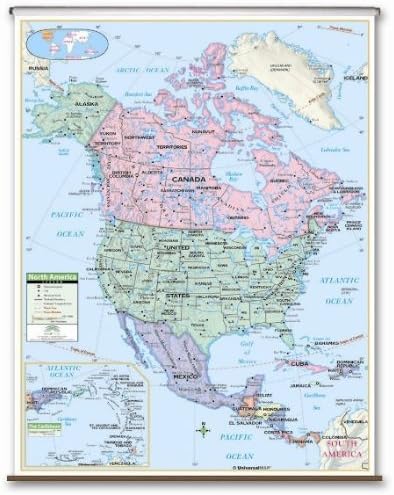
The North America Primary Classroom Wall Map by Classroom Maps AtoZ has a laminated and markable-washable surface. Measures 54 in. x 69 in. and features color-coded countries. Includes national capitals and boundaries, cities, latitude and longitude lines, and mountain peaks. The area of coverage ranges: North: to the Arctic Ocean, Greenland; South: to the Pacific Ocean, Panama; East: to the Atlantic Ocean, Dominican Republic; West: to the Pacific Ocean. Mounted on roller. This map is ideal for school use in public school, private school, parochial school, and home school's classrooms. Map hanging hardware needed? No. This map has brackets for a wall mount. If you are looking for a wipeboard/chalkboard mounted map, search the store for this map with a backboard.
Common Questions
Trustpilot