🧭 Navigate your next adventure with precision and style!
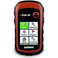
The Garmin 010-00970-10 eTrex 20 is a compact, lightweight handheld GPS unit featuring a responsive touchscreen and Garmin’s trusted navigation technology, designed to provide reliable outdoor location tracking in a durable, portable form factor.


| Manufacturer | Garmin |
| Item model number | 010-00970-10 |
| Product Dimensions | 3.3 x 10.16 x 5.33 cm; 141.75 g |
| ASIN | B00542NVDW |
| Guaranteed software updates until | unknown |
C**L
Destined for classic status
If the Garmin eTrex Series of GPS's had been capable of displaying OS Mapping before now I would never have purchased any other GPS handheld as they are superb little devices.Because of this previous lack of mapping capability I purchased a Satmap Active 10 and later a Garmin GPSMAP 62S.Both units were capable of displaying OS Maps, and each had its merits.Unfortunately the Active 10 was useless in bright sunlight, and needed constant access to a Nuclear Power Station in order to provide the energy to run it, while the GPSMAP 62S was the size and weight of a house brick.What I needed was a GPS that combined the following:1. Compact and lightweight design2. Screen clarity in bright sunlight3. Low battery consumption4. Ability to display OS MappingI purchased the eTrex 20 a few days ago, and after taking it out of the box my initial thought was that it was a toy - based purely on the weight of it compared to my GPSMAP62S.After that ridiculous assumption I really scrutinised the new gps.The build quality is truly superb. The casing did not creak when I pressed the power on button, as it does on my GPSMAP62S. Aesthetically and ergonomically it really does take some beating. All the edges are rubberised, making for very secure handling. It is so well designed that you really can operate it with one hand.The menu structure is intuitive, and within thirty minutes you should have a good understanding of how the unit operates.The eTrex 20 not only uses the American GPS Satellite System but also the Russian `GLONASS' system, which logs your location very quickly.It is also EGNOS enabled.Wasn't he that kid on Britain's Got Talent?At this point let me dispel a couple of myths that I have seen on various reviews regarding the eTrex 20.If you purchase any Garmin maps on an sd card the mapping is locked to the card and not to the unit. It is only locked to the unit if you acquire your mapping by other means - download from Garmin, DVD etc.I took my Garmin all GB Discoverer mapping sd card from my GPSMAP 62S unit and it worked fine in the new eTrex 20, with no issues.The moral here, when wishing to transfer your OS mapping between Garmin units, is to purchase it on SD CARD ONLY!Another myth is that you can only measure distance as the crow flies; in reality you can achieve very accurate measurement of distance by doing the following:From the map page press the submenu button on the left hand side of the unit beneath the zoom buttons. From the resulting popup menu select Measure Distance. Another little popup appears in the bottom right hand corner, which displays a cumulative total.The tip of the little blue triangle is the first point of reference, and as your move the joystick a white arrow appears with what looks like a piece of string connecting them. Move the white arrow and place it just before the first `bend' in the road or path you wish to measure, then `click' the joystick. Follow the contour of the bend, clicking several times to match the shape of it. Carry on by clicking the joystick just before the next bend - this will have measured the `straight' section between the bends, and you can then follow the contour of the next. Do this to the end of the road or path and you will see a very accurate total distance displayed in the bottom right hand corner.I would never review a gps unless I had tested it thoroughly in the field first, which is what I did yesterday on a very cold and wet, twelve mile walk.The eTrex 20 performed exceptionally well in all aspects of gps navigation. Having clipped it to the chest strap of my rucksack it was subjected to continual driving rain. After six hours the battery life indicator had not moved at all. I measured sections of path, cleared the track log, and then set off along those measured sections. The distance logged by the unit was very close to the distance that I had measured.Before setting out I had downloaded to the unit two geocache locations (I am not into that sort of thing but wished to test it) and found both of them with no problems. Paperless geocaching was effortless.Some would say that the small screen size of the eTrex 20 is not conducive to the using of OS Mapping - rubbish!When walking in Shropshire I do not wish to be able to see The North York Moors as well. If you need a wider view zoom out; if you need more clarity zoom in.As with some other Garmin units the eTrex 20 has a fixing spine on the back - you slide onto this an attachment with a connected carabiner or a round nodule that slots into a belt or chest clip. Despite my GPSMAP62S being a lot bigger than the eTrex the sliding attachment appeared to be the same size. I was surprised when I found how `tight' this attachment was on the smaller unit - you really have to push quite hard to attach it to the fixing spine.Many people have made comments about the old and the newer eTrex gps devices; stating that you could accidentally move the joystick when the unit was placed in the pocket. To avoid anything happening as a result of this, first select the 'satellite' page then set the backlight to zero - this acts as a 'virtual' joystick lock!If you are looking for a mid-priced OS Mapping enabled gps buy the eTrex 20 because this little gem is destined for `classic' status.Update:I have been asked to add a footnote.After using the eTrex 20 on three occasions I found myself inserting my GB OS Mapping card into my Garmin GPSMAP 62s because of its larger screen size. This might seem at odds with the comments made previously by me, but given time you do realise the limitations of using OS Maps on a small screen.However, if you start off by using an eTrex 20 such things will not be an issue.I still rate this little unit, and stand by my comment that it will in time attain 'classic' status.
W**S
My First GPS
I love this little device.I ordered a used one from the Amazon Warehouse and managed to get a great deal. It came packaged as new and i honestly wouldn't have been able to tell it from a brand new one - so well pleased on that score.First point is, in keeping with lots of other users reviews on here - there's nothing to speak of in terms of a user manual. I think this may be because a). to provide one with adequate scope to cover units potential would be pretty largeb). the fact that you're buying a GPS signifies that you're up for a bit of adventure and tbh i have enjoyed experimenting & doing some digging online to see what i could come up with.Couple of VIPs - firstly the unit is really small, so i prob wouldn't recommend it as an auto GPS, you can mount it on your dash but you will be squinting too much i feel. Secondly don't expect fireworks in terms of the maps it's supplied with, they are v basic road maps of UK &Euro (non routable) so dont expect highly detailed 1.25000 style OS contoured maps. If you want detailed maps from Garmin or OS you will be forking out much more than the cost of the unit, i think thats already been mentioned on here numerous times.Fortunately, due to OpenStreetMap, this is not a problem - i downloaded for free, the whole of the UK routable maps that are accurate enough to hike in the mountains with ~(although i have yet to test this, i fully intent to soon).They look very detailed (but not beautiful OS quality)Once loaded,i switched my unit on and wandered round town and loads of POIs (points of interest) appeared - banks, bars, shops etc. Brilliant.I also bought a 32 gig Micro SDHC card for 20 quid, so have expanded the memory too.You have to be patient and experiment as i said, for example i downloaded coordinates for 3000 european ACSI campsites from ACSI.eu which was great, until i discovered that i had saved them as waypoints instead of POIs and as a result couldn't add anymore routes. (Routes are combinations of waypoints & you only have a limited number of waypoints - for processing reasons). This was easy enough to rectify though. So you need to manage your data correctly and get familiar with Garmin BaseCamp software and POI Loader - both free Garmin programs that will help you do this.I am honestly not PC savvy but you have to go nerd for a few days - there are loads of helpful tutorials on youtube to assist you in this. In essence you have lots of(but finite) capacity for creating and storing routes and if you put a card in the expansion slot you have space for tens of thousands of POIs - so it shouldn't in any way limit what you intent to do. (Geocaching i have no interest in unfortunately).I intend to use the unit in the mountains, so tested it with gloves on - fine, no probs operating it (even though i am left-handed and the toggle button is on the right).It's also robust and fully weather proof. Battery life appears good, but one gripe is that the battery life indicator can actually increase again depending on, for example, if you set the backlight on its lowest setting. In my eyes it should be a linear thing - the indicator goes down as and when unit discharges, and shouldnt suddenly go back up again. Thats my only gripe and from what i have read, if used conservatively, the battery life is very good - carry a spare set if necessary x2 AAs.I guess i-phone users will be wondering why they would bother getting a dedicated GPS, but try operating a touch screen i-phone on a mountain at -10 degrees in driving sleet. Good luck. And also when on extended back country trips where are you going to charge your phone?... In short a great powerful,light weight & compact unit. But be prepared to put some hours in discovering it's potential.
H**L
A machine with its own mind. On the whole an ok buy, but not user-friendly and navigation can be erratic.
On the positive, like many other users said: It is sturdy and can take a hit. It is waterproof. It is compact. It has a long battery life.On the negative: Obviously the basemap it comes with is crap, so you have to get other maps. Some are download-able for free. Its software is not user-friendly nor self-explanatory, unlike mobile phones. The manual is rudimentary and inadequate. It took me several hours to understand how to work this machine. For example, if you want to put an address as a waypoint but customize it to a friends name, then you need to use three different apps on the machine to do that. That takes a bit of time to work out, especially as the manual does not say anything how to do it.With that I went to Germany on my cycle to visit friends. I found that , if I used the 'route planner", it calculated the mean between two waypoints and navigated me off track. When I used a single waypoint, it could decide on route to recalculate a different way and send me on detour. I always got where I wanted to go in the end, but needed to cycle extra miles (good for my physique). Also display is understandably small, so you wont have an overview really.Overall, not great, but workable. I guess at some point, there will be better options on the market for that price.
Trustpilot
1 week ago
3 weeks ago